Estancia Moat is located on the Northern rim of the Beagle Channel, East of Estancia Harberton. Its Northern limit is determined by an imaginary line that runs WNW to ESE and has a correction angle located 5.200 m away from the NW angle (i.e., a similar direction to that followed by the Beagle Channel).
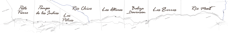
The area of the Estancia is 8.100 hectares, which comprise eight different estates: Poste Fierro, Pampa de los Indios, Los Potros, Río Chico, Los Altares, Baliza Davinson, Los Zorros and Río Moat. The distance between Poste Fierro and Río Moat is close to 30 km, and the actual extension of the coastline between those two points, of almost 37 km. The distance that separates the Beagle Channel and the Northern limit of the Estancia varies between 2 and 2,8 km.
The area occupied by the estates is, essentially, the Southern hillside of the No Top and Sin Nombre ranges. The average height of these ranges is about 500 m and both are characterized by the absence of identifiable peaks. The Valley of Río Chico, that separates both, constitutes the most important discontinuity of the Estancia.
The estates located West of the valley extend over a relatively steep slope, whose orientation varies from SSW (Poste Fierro) to SSE (western side of the Río Chico valley). In that sector, the hillsides have a quite continuous slope, and most of the flat areas are located in the lower parts and next to the coast. The estates of the eastern side have a softer slope that diminishes as we get away of the valley. At the same time, the orientation of the slope changes slowly until reaching, on the proximities of Baliza Davinson, an ESE orientation.

